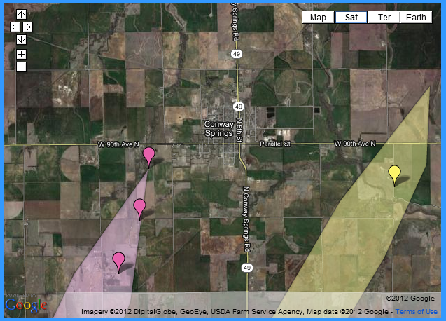
On Saturday evening a the National Weather Service in Wichita was receiving reports of a large, violent tornado moving toward the city of Conway Springs, KS. Based on the protocol of the Impacts Based Warnings pilot program, the local NWS office issued a Tornado Emergency for Conway Springs. (The text of this warning, including the line
can be found below.) Fortunately for the residents of Conway Springs, a devastating tornado failed to occur. The original tornado that prompted the tornado emergency weakened and dissipated to the west-southwest of Conway Springs. A second tornado developed to the southeast of the original tornado and moved to the east-northeast and missed Conway Spring to the east.
Above is the image from the NWS Wichita, KS homepage. (Original image can be found on this page). It clearly shows that Conway Springs was spared from damage from the tornadoes. Based on how I have defined tornado emergencies in my research, this (potentially) would be considered a successful Tornado Emergency, as a tornado occurred within the bounds of the tornado polygon. (It’s “potential” depending on what tornado intensity threshold you want to use for a tornado emergency.)
However, since the Severe Weather Statement that announced the Tornado Emergency specifically stated,
should this be considered a successful Tornado Emergency, even though the city was not hit? What if you lived in Conway Springs, heard from the local TV station that this was a Tornado Emergency and a “Catastrophic Warning”, as at least one Wichita television station said, and decided that your best bet is to get into your car and leave town? If you drove west, south, or east, chances are you might have driven into one of the two tornadoes, whereas staying at home would have spared you. Would that person consider this a successful Tornado Emergency? I would speculate that he or she would not, as I know I would not. All of these are scenarios and questions that we do not have answers for. This is why the Impacts Based Warnings pilot program should have engaged social scientists and researched before being tested operationally.
I’ll reiterate my position:
The text of the Severe Weather Statement issuing a Tornado Emergency for Conway Springs, KS.
815
WWUS53 KICT 150236
SVSICT

SEVERE WEATHER STATEMENT
NATIONAL WEATHER SERVICE WICHITA KS
936 PM CDT SAT APR 14 2012

KSC191-150300-
/O.CON.KICT.TO.W.0029.000000T0000Z-120415T0300Z/
SUMNER KS-
936 PM CDT SAT APR 14 2012

...A TORNADO WARNING REMAINS IN EFFECT FOR NORTHERN SUMNER COUNTY
UNTIL 1000 PM CDT...

...TORNADO EMERGENCY FOR CONWAY SPRINGS...

AT 932 PM CDT...A CONFIRMED LARGE...VIOLENT AND EXTREMELY DANGEROUS
TORNADO WAS LOCATED 5 MILES SOUTHWEST OF CONWAY SPRINGS...AND MOVING
NORTHEAST AT 35 MPH.

THIS IS A PARTICULARLY DANGEROUS SITUATION.

HAZARD...DEADLY TORNADO.

SOURCE...SPOTTER CONFIRMED TORNADO.

IMPACT...THIS IS A LIFE THREATENING SITUATION. YOU COULD BE KILLED IF
         NOT UNDERGROUND OR IN A TORNADO SHELTER. COMPLETE
         DESTRUCTION OF ENTIRE NEIGHBORHOODS IS LIKELY. MANY WELL
         BUILT HOMES AND BUSINESSES WILL BE COMPLETELY SWEPT FROM
         THEIR FOUNDATIONS. DEBRIS WILL BLOCK MOST ROADWAYS. MASS
         DEVASTATION IS HIGHLY LIKELY MAKING THE AREA UNRECOGNIZABLE
         TO SURVIVORS.

LOCATIONS IMPACTED INCLUDE...
WELLINGTON...CONWAY SPRINGS...BELLE PLAINE...WELLINGTON AIRPORT AND
RIVERDALE.

PRECAUTIONARY/PREPAREDNESS ACTIONS...

TO REPEAT...A LARGE...EXTREMELY DANGEROUS AND POTENTIALLY DEADLY
TORNADO IS ON THE GROUND. TO PROTECT YOUR LIFE...TAKE COVER NOW. MOVE
TO AN INTERIOR ROOM ON THE LOWEST FLOOR OF A STURDY BUILDING. AVOID
WINDOWS. IF IN A MOBILE HOME...A VEHICLE OR OUTDOORS...MOVE TO THE
CLOSEST SUBSTANTIAL SHELTER AND PROTECT YOURSELF FROM FLYING DEBRIS.

TORNADOES ARE DIFFICULT TO SEE AND CONFIRM AT NIGHT. TAKE COVER NOW.

&&

LAT...LON 3748 9781 3747 9715 3730 9715 3706 9780
TIME...MOT...LOC 0235Z 213DEG 30KT 3735 9768

TORNADO...OBSERVED
TORNADO DAMAGE THREAT...CATASTROPHIC
HAIL...2.50IN

$$
